What to Understand When Square Waves Appear Across the Ocean
For many people, time beside the sea is one of the great attractions of warm seasons, vacations, and summer journeys. A coastline can be a place to swim, surf, take a boat out, walk on the sand, or simply watch the horizon. Yet the ocean is never a fixed setting. Wind, tides, currents, changing weather, waves, and the shape of the seabed can all affect what occurs close to shore.
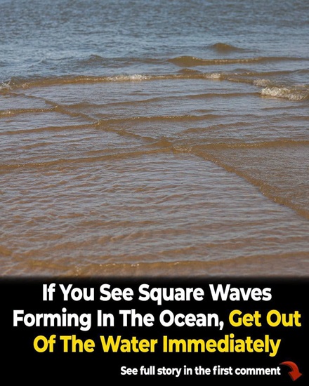
One of the more unusual surface patterns occasionally seen at sea is widely called “square waves” online. Scientists and mariners generally refer to the condition as a cross sea. Despite the popular nickname, the water is not arranging itself into exact geometric squares. The checkerboard effect appears when two separate systems of waves meet and overlap.
A cross sea forms when waves traveling along different paths occupy the same stretch of water simultaneously. Swells can move across very long distances after the wind that created them has faded or remained far away. A swell from one weather system may therefore enter an area where another group of waves is already present. A shift in local wind can produce a new pattern while an earlier swell continues on its original course.
When those systems intersect at clearly different angles, their crests cross and may trace a surface grid that resembles diamonds or squares. The visual effect can be especially pronounced when the two directions are near a right angle. From above, the sea may briefly look like an enormous checkerboard in motion.
Images and videos of cross seas attract attention because the pattern looks so unexpected. Social posts often describe them as mysterious square waves, making the surface seem almost artificial or deliberately organized. The actual explanation comes from changing weather and wave mechanics. Both groups of waves continue moving and influencing one another, so the grid never becomes a permanent structure. One system may eventually lose energy, turn, or leave the area, and the orderly-looking design then fades. A photograph captured at the ideal instant can make the phenomenon seem more fixed and dramatic than it really is.
Researchers who study maritime safety are interested in crossing waves because they can produce complicated motion for ships. A vessel at sea responds by rolling, pitching, rising, falling, and moving in other ways. When waves arrive from more than one direction, those movements can be harder to anticipate and control. Studies of accidents in severe weather have identified combinations of wind-driven waves and swell as factors that deserve attention when evaluating hazardous sea states.
A 2004 investigation into dangerous ocean conditions and shipping accidents found evidence that rapidly building seas, together with certain mixtures of wind waves and swell, may contribute significantly to risk. That does not mean every cross sea will cause a vessel to be lost. It does show why multidirectional wave fields matter to the people responsible for marine forecasting, ship design, and safe operation.
For large vessels in open water, intersecting swells may become extremely uncomfortable and potentially dangerous when the overall sea is already severe. Waves striking from separate directions can intensify rolling and create complicated combinations of motion. Researchers study these conditions to improve forecasts and understand how ships behave during difficult operations.
Many details determine how serious a particular situation is: the height and period of the waves, their directions, wind strength, vessel construction, and the wider sea state all matter. A photograph showing a grid on the surface is therefore not enough to measure the actual danger. Professional crews use detailed marine forecasts and operational data rather than drawing conclusions solely from appearance.
Some online warnings make a much broader claim, suggesting that any swimmer who notices square waves must assume a deadly current is directly underneath. That statement lacks important context. Powerful crossing seas offshore can certainly create harsh conditions, but a small crossed pattern near a beach does not automatically expose a swimmer to the same hazards faced by a ship in a violent open ocean.
Reports examining the viral warnings have specifically noted that treating every visible cross sea as an immediate mortal threat to swimmers can mislead the public. For an individual at the beach, local wave size, currents, weather notices, wind, underwater terrain, and advice from lifeguards or coastal authorities are much more useful indicators of safety.
It is also important not to confuse cross seas with rip currents, which are a different marine hazard. A rip current is a concentrated stream of water flowing away from shore. It can endanger swimmers by carrying them farther out, yet it may not create the striking checkerboard pattern associated with intersecting waves. From the beach, a rip can sometimes be difficult to identify at all.
Unusual wave shapes should never be treated as the only sign that swimming may be unsafe. Before entering unfamiliar water, checking posted beach flags, local forecasts, official warnings, and lifeguard instructions remains one of the most practical precautions. The absence of a square-looking pattern is not proof that no hazard exists, just as its presence is not a complete diagnosis of conditions below the surface.
Île de Ré, an island near La Rochelle off France’s Atlantic coast, has become particularly well known through photographs of cross seas. Elevated observation points around the island allow the crossing systems to be seen more clearly, because their geometry is easier to recognize from above than at the waterline. Pictures made there helped turn “square waves” into a familiar internet expression.
Educational explanations frequently cite Île de Ré, but the island is not the only place where the pattern can occur. Wherever two suitable wave systems intersect, crossed seas may develop in oceans around the world. The French island simply offers viewpoints and conditions that have produced memorable images.
Visitors should not expect its waters to display perfect diamonds every day. Marine conditions continually evolve, and the visibility and intensity of intersecting crests depend on which swells and winds are affecting the area at a particular time. Île de Ré has ordinary swimming beaches and surfing areas in addition to the occasional surface pattern made famous in viral photography.
Official tourism guidance for the island tells people taking part in water activities to consult tide and weather information and use appropriate safety precautions. Certain nearby surf breaks can generate powerful waves and are recommended specifically for experienced surfers. That local advice is far more meaningful than a universal rule attached to a dramatic picture.
Another spectacular encounter between bodies of water is visible at Cape Reinga, also called Te Rerenga Wairua, in the far north of New Zealand. The country’s Department of Conservation explains that currents linked with the Tasman Sea and the Pacific Ocean come together offshore over the Columbia Bank. Their interaction may produce broken water, spray, foamy expanses, and waves that appear turbulent.
The scene is famous for its power, but it should not automatically be presented as identical to every photograph labeled square waves. The meeting of currents and the crossing of wave systems both involve complex marine processes, yet unusual-looking surfaces are not scientifically interchangeable merely because photographs of them appear dramatic.
Cape Reinga also holds meaning that extends far beyond ocean science. Te Rerenga Wairua is deeply significant in Māori culture, and the Department of Conservation asks guests to honor the protocols connected with the place. People visit the lighthouse and surrounding landscape to see the meeting waters safely from land rather than approaching the rough sea offshore.
Official descriptions emphasize that the region can experience strong winds, heavy surf, and quickly changing conditions. The combination of environmental exposure and cultural importance is a reminder that remarkable coastal scenery should be approached with respect for both local guidance and the place itself.
Scientists explore crossing waves with mathematical models designed to represent the interaction of separate wave fields. The real study of nonlinear ocean behavior is far more involved than the short explanation usually posted beneath a viral image. Fluid-dynamics equations can help describe how direction, wind, wave energy, and other variables influence the way a cross sea develops.
The Kadomtsev–Petviashvili equation, commonly shortened to the KP equation, belongs to a group of mathematical tools used when investigating nonlinear waves. Still, calling every picture of a square-looking ocean simply “the KP equation in action” reduces a complex subject too far. Real seas contain numerous physical processes operating together and often demand richer models, measurements, and observations.
Cross seas remain visually compelling partly because people expect waves approaching a coast to form more or less parallel lines. A second set of crests moving across that familiar direction contradicts the normal image of how surf should behave. From a tower, cliff, aircraft, or other high position, intersections can look astonishingly regular and create moving rows of diamonds.
At beach level, the geometry may be much less obvious. Perspective compresses the wide surface, hiding the pattern that stands out in aerial or lighthouse photography. A person in the water may never see the same neat design captured from above, even while both wave systems are present. The viewpoint is a major reason online pictures look so extraordinary.
Weather far beyond the visible coast can also shape what reaches a beach. Swells carry energy out of the region where the generating wind first acted and can continue over great distances. If another wind field or swell enters from a separate direction, both systems can share the same area.
This means that clear or calm-looking weather directly overhead does not always account for all waves arriving along a shoreline. The sea can carry a record of storms and winds occurring elsewhere, well beyond anything a visitor can see from the sand. A cross sea may therefore be the visible result of weather histories converging.
For swimmers, surfers, and recreational boaters, the reasonable lesson is respect rather than automatic panic. Large, confused, or multidirectional waves can be hard to manage, and inexperienced people should never assume visually striking water is harmless simply because the sky appears pleasant. At supervised beaches, local warning systems and lifeguard directions offer better safety information than simplified rules passed around on social media.
Boat operators likewise need official marine forecasts, knowledge of their craft, and an honest assessment of expected conditions. Cross seas are one part of a broad safety picture, not a universal signal that an accident is imminent. Experience, equipment, vessel limits, wind, currents, and wave characteristics all affect the correct decision.
Wave height is especially important. Two modest systems crossing in shallow coastal water are not equivalent to powerful swells arriving from different directions around a ship far offshore. Research into maritime accidents evaluates many connected factors. It does not say that the mere appearance of a checkerboard will instantly drag every nearby swimmer beneath the surface.
Removing that scientific context and converting it into a frightening universal claim produces bad safety communication. Accurate guidance should recognize that severe crossing waves can present real risk while avoiding claims unsupported by the actual local conditions. Exaggeration can distract people from hazards such as rip currents, rapidly changing weather, or beach-specific warnings that genuinely require their attention.
The subject is a useful example of what happens when a beautiful natural event spreads online. A spectacular picture gains attention, someone attaches an alarming warning, and the warning is then repeated after its scientific limits have disappeared. Cross seas deserve caution when the wave field is strong, yet they are fascinating without sensational additions.
Their genuine physics is already remarkable. Swells born from different winds and weather systems can cross miles of ocean, enter the same region, and combine into a surface that appears unexpectedly organized. What resembles a human-made grid is actually the temporary expression of moving energy arriving from separate directions.
Observed from a safe point on land, a cross sea can be an extraordinary spectacle. It demonstrates that the ocean is not just one orderly procession of waves heading toward shore. Each swell has its own origin, period, speed, wavelength, energy, and course. The visible surface is the combined result of all those influences. A geometric-looking patch of water hints at processes operating across far larger distances than a single photograph can show.
Safe decisions at any coast ultimately depend on present local conditions, not one visual slogan. Swimmers need to consider warnings, current strength, wave behavior, sudden weather changes, and their own skills. Surfers should understand the break they are planning to enter. People operating boats require appropriate forecasts and enough experience for the expected sea state.
When water looks unusually rough, confused, powerful, or unpredictable, staying on shore until it improves may be the safest response. Respecting the ocean does not require inventing a single rule for every location. It requires paying attention to reliable information and accepting that conditions can change quickly.
So-called square waves—more accurately, cross seas—are both scientifically interesting and deserving of sensible caution. They emerge when different wave systems intersect and sometimes form the memorable checkerboard patterns photographed at locations such as Île de Ré. Strong crossed seas can add to challenging and hazardous conditions for vessels, especially when other elements of the sea state are already severe.
At the same time, it is incorrect to insist that every small intersecting pattern close to a beach is automatically deadly for swimmers. Understanding that distinction allows people to appreciate one of the sea’s strangest sights without replacing practical safety advice with fear.
The ocean is spectacular precisely because it remains complicated, dynamic, and different from moment to moment. Cross seas reveal that complexity by transforming familiar swells into something that can look intentionally designed. The real science is more compelling than the frightening myths frequently placed beside viral images. When conditions are uncertain, reliable local guidance, respectful distance, and observation from a safe viewpoint allow people to witness the phenomenon while keeping its actual risks in perspective.