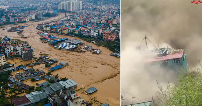
A disastrous flash flood and debris surge on the mountainous frontier between Nepal and Tibet has killed many people, erased parts of communities, and left a large number of others unaccounted for. The event struck on August 26, 2026, when a huge mass of water, ice, mud, stone, and debris tore through narrow Himalayan settlements and valleys. Early official reports placed the death toll above 160, but the figure rose sharply as rescuers gained access to more damaged locations. Reuters reported the next day that at least 359 people had died and close to 1,000 were still missing across Nepal and China. Search and recovery work continued, so none of those casualty totals could yet be treated as final.
Rasuwa district, near Nepal’s border with Tibet, suffered some of the heaviest destruction on the Nepalese side. The flood traveled through connected rivers with tremendous power, pushing wreckage downstream and harming places far from the original collapse. Settlements beside the Bhote Koshi and Trishuli systems were inundated as muddy water and debris moved south. Houses, roads, shops, bridges, and other essential structures were ruined. Steep terrain and severed access routes prevented emergency crews from immediately reaching several communities.
Reports from the opening hours illustrated how quickly the known facts evolved. Nepal Police first said that 162 bodies had been recovered in multiple flood-stricken districts. Officials later raised that count to 165 when more victims were found. As teams searched farther downstream and finally entered previously unreachable areas, the verified toll climbed much higher. This pattern matters because preliminary figures after a vast natural disaster are usually incomplete snapshots, not settled conclusions.
Nepalese authorities deployed security forces and disaster personnel for rescue, search, and victim-recovery operations. Helicopters played a crucial role because broken roads and difficult mountain geography kept ground vehicles away from some sites. Crews searched riverbanks and crossed zones buried beneath mud and rubble. They worked to save survivors, locate those who had vanished, recover the dead, and move injured residents to hospitals. Unstable slopes and extensive damage made every part of that response harder.
Visitors from other countries were also caught in the emergency. Nepal serves as a major entry point for travelers headed toward Himalayan trekking paths and sacred destinations, including the Kailash Mansarovar routes in Tibet. Many people first listed as missing had joined organized tours or pilgrimage groups. Because of that international presence, foreign governments and diplomatic missions began checking records and trying to establish whether their nationals were safe.
During the early response, the Nepal Tourism Board said hundreds of visitors could not immediately be located. One government update identified 579 missing tourists: 466 were foreign nationals and 113 were Nepalese. Those totals reflected only the information known at that stage and did not mean every listed person had died. In a rapidly changing crisis, someone recorded as missing may later contact relatives, be rescued, or turn out to have traveled elsewhere.
Separate updates sometimes gave different counts for particular nationalities. That is why missing-person and casualty data must be connected to the authority that issued it and the moment it was released. Tour companies, embassies, municipal offices, and disaster agencies can begin with different passenger manifests and registration databases. Investigators then compare those lists, remove duplicate names, and establish whether people who were initially unreachable have since made contact.
The United States said its embassy in Kathmandu was coordinating with Nepalese officials and partner organizations to help Americans affected by the disaster. Initial reports offered conflicting estimates of how many U.S. citizens could not be reached. The State Department therefore declined to present uncertain early totals as established fact while diplomats continued investigating the status of travelers believed to be in the region.
Canada also followed the emergency after reports indicated Canadian visitors might be involved. Canadian authorities noted that voluntary overseas registration can assist during a crisis but cannot show precisely how many citizens are physically inside a disaster zone. Some travelers never enroll, and others remain registered after changing their itinerary. Registration data therefore should not automatically be described as either a list of missing people or a casualty count.
Governments elsewhere began similar efforts to find their citizens. People from India, Britain, Australia, Malaysia, and additional countries appeared among those initially unaccounted for, many of them tourists or pilgrims. Embassies and travel operators worked with local authorities to match itineraries and names against lists of people already located. India faced particular concern because so many Indian travelers visit Himalayan religious sites, and states near Nepal increased alert levels as the scale of the damage emerged.
The flooding showed how quickly a disaster in the Himalayan river network can acquire international consequences. Waterways, roads, trade corridors, and tourism routes connect areas across national borders. A collapse beginning high in one remote valley can threaten residents, visitors, and infrastructure far downstream and in more than one country.
Tibet also reported severe devastation. Chinese authorities described deaths and hundreds of people missing, including travelers from abroad. Gyirong, an important crossing that links Tibet and Nepal, was among the badly struck areas. The rapidly advancing debris hit buildings, vehicles, and public infrastructure. Teams on that side of the frontier confronted the same basic obstacles as Nepalese rescuers: damaged approach roads, dangerous slopes, and terrain that could shift again.
Photographs and video captured the extraordinary physical force of the event. Thick masses of mud and broken material swept around buildings and through valleys, overpowering vehicles, bridges, and roads. Such visual evidence can document the scale of destruction, but images alone cannot establish reliable casualty figures or identify the geological trigger. Those findings require official field work, scientific analysis, and verified reporting.
The cause became one of the most important developing parts of the story. Initial information raised the possibility that an earthquake had contributed to the flood. The U.S. Geological Survey first detected and registered a signal near the Nepal–China frontier that resembled seismic activity. Later examination, however, changed that interpretation substantially.
USGS specialists analyzed readings from surrounding stations, long-period seismic waves, and satellite observations. Their updated assessment found that an earthquake had not produced the signal. Instead, the agency concluded that the vibrations came from the collapse of a glacier together with the debris movement that followed. Continuing to repeat the original earthquake theory after that correction would misrepresent the scientific evidence.
Satellite data then offered further indications of the collapse’s enormous size. Analysis cited by the Associated Press showed that part of a Himalayan glacier, along with underlying bedrock, had broken away. A vast quantity of ice, rock, and other mountain material accelerated downhill. After entering the drainage network, the mass helped create a violent surge that gathered still more sediment and wreckage as it moved downstream.
Himalayan geography can make events of this kind exceptionally lethal. Debris gains great speed on steep slopes, while confined valleys focus the flow instead of allowing it to spread harmlessly. Once the moving mass enters a river, communities many kilometers away may face danger with almost no warning. Roads, homes, and businesses are commonly concentrated on valley floors because there is little flat land available for building.
Reports said the first surge entered the Lhende Khola, continued into the Bhote Koshi, and ultimately reached the Trishuli river system. Water rose dramatically in a short span. Downstream communities were therefore struck by much more than ordinary river flooding: the flow contained rocks, sediment, broken structures, and other heavy debris. That mixture can hit with far greater destructive force than water by itself.
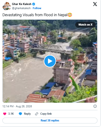
Transport links suffered major losses. Government assessments described dozens of damaged bridges, including crossings for vehicles and suspended footbridges, while long portions of roadway were also affected. Destroyed access creates a second emergency after the initial surge, because standard rescue vehicles cannot travel to isolated settlements and supplies cannot move along their usual routes.
Electricity and hydropower infrastructure were harmed as well. Nepal depends heavily on power generated by rivers, leaving plants, transmission systems, and related facilities exposed when floods and landslides strike. Damage can cut electricity precisely when medical services and recovery operations need it most. Officials therefore had to evaluate urgent humanitarian needs alongside the longer restoration of essential infrastructure.
Broken roads also raised serious economic concerns. Routes connecting Nepal and Tibet carry commercial freight as well as tourists. Damage to customs points, bridges, and transport corridors may interrupt trade long after the rescue stage ends. Families who earn income from travel, trucking, shops, or related businesses could endure lasting losses even where their own houses were spared.
For people in the affected valleys, the first concern remained missing relatives and neighbors. Families searched medical centers, shelters, evacuation sites, and emergency offices for information. Survivors described being separated when the flood arrived with little warning. Some escaped only as homes and nearby buildings were swept away, buried, or torn apart.
The physical search was immense. Mud can blanket a wide area and erase the visible outlines of houses, vehicles, and roads, making it difficult to know where to dig. Heavy machinery is rarely available immediately in remote mountain settlements. Even when it can be delivered, washed-out roads, shifting ground, and unstable hillsides can make operation dangerous.
Aircraft consequently became indispensable in parts of the response. Nepalese military helicopters evacuated people from places no longer reachable by road. One government report said more than 100 Nepalese and foreign nationals were flown to safety from the Timure area. Helicopters also carried food, medical materials, other emergency supplies, and response personnel into isolated zones.
Weather and mountain conditions continued to threaten rescuers and residents. Rain can rapidly destabilize slopes already weakened by a huge debris event, and conditions at altitude can change without much notice. Emergency commanders had to protect their own teams while trying to reach survivors. Sending crews into an unchecked valley could expose them to a second collapse, landslide, or flash flood.
Officials also watched for renewed downstream flooding. Landslides and debris can block a river and form a temporary natural dam. Water gathers behind the obstruction until it overtops or breaks through, potentially releasing another destructive wave. Monitoring upstream blockages therefore became essential to the safety of both communities and rescue teams.
Residents near at-risk riverbanks were advised to leave vulnerable locations. Those instructions were precautionary while experts assessed the altered channels and unstable debris. Danger can persist after the first surge because ice, mud, and rock continue to change the direction and volume of normal water flow.
The event has focused attention on the vulnerability of communities living near glacier-fed Himalayan waters. Tens of thousands of glaciers across the Hindu Kush Himalayan region supply rivers that support enormous populations. Ice naturally advances and retreats, but researchers have documented significant warming and widespread glacier loss throughout the area. Climate change belongs in the wider scientific discussion of regional stability, though long-term trends must be distinguished from a final explanation of one specific collapse.
Scientists have warned that higher temperatures can accelerate glacier retreat, thaw permafrost, and weaken mountain slopes. Those changes may increase hazards connected to glacial lakes, landslides, ice, and falling rock. In this disaster, initial geological evidence identified a large collapse involving both glacier and bedrock as the immediate trigger. Determining every condition that made the failure occur will require a much deeper investigation.
Assigning every feature of this particular event to a single cause before that study is complete would be premature. What researchers can state with greater confidence is that the high-mountain environment is undergoing substantial change. Warming has affected glaciers across the Himalayas, and experts have repeatedly called for stronger monitoring of hazardous locations.
Satellites, river gauges, seismic sensors, and warning networks can help authorities detect certain risks as they develop. No system can stop a glacier from breaking apart, but a timely alert can sometimes give people downstream a chance to reach higher ground. Even a brief warning matters when a dense debris surge is rushing through a narrow river valley.
Useful warning systems require more than instruments. They also depend on working communications, trusted local alerts, mapped evacuation paths, and procedures that residents know before an emergency begins. The Nepal–Tibet catastrophe demonstrates the difficulty: a failure high in a remote range can become a massive flood before settlements many kilometers away understand its source. Power and telephone service may then disappear at exactly the moment reliable information is most urgent.
International cooperation can be especially valuable under those conditions. Nepal has long experience with earthquakes, landslides, and floods, but a disaster spread across a broad area can exceed local capacity. Humanitarian groups can supply shelter, drinking water, medicine, sanitation support, and food while national agencies concentrate on lifesaving operations and damaged infrastructure.
Foreign governments also carry responsibilities toward citizens visiting the region. Embassies can contact tour organizers, exchange information with local officials, help worried relatives, replace lost travel documents, and assist survivors who need to leave. They must also explain uncertainty honestly. A name on a missing list is not equivalent to a confirmed death.
Groups can become separated during evacuation, mobile networks can stop working, and people may arrive safely elsewhere before they are able to call. Missing totals can fall once communications return and lists are reconciled. Confirmed death counts may move in the other direction as teams reach communities that were previously cut off and recover more victims.
That pattern appeared during Nepal’s first day of reporting, when the known toll was revised several times. Careful journalism should label such figures as current estimates rather than imply permanence. It should also identify the agency and reporting time behind each update so readers understand why later accounts may contain different numbers.
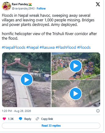
Social media creates another challenge during a fast-moving disaster. Powerful images can reach millions of viewers before authorities have determined the nature or size of the event. Authentic footage can be posted beside photographs from an unrelated flood years earlier. Unverified casualty figures may continue circulating even after investigators have corrected them.
Police, scientific organizations, established news outlets, and disaster-management agencies are therefore especially important sources during an evolving emergency. Their statements can still change when new evidence emerges, as happened when the early earthquake interpretation gave way to the glacial-collapse assessment. Correcting an initial explanation in response to stronger evidence is a mark of accurate reporting, not a reason to preserve the outdated claim.
The difference between those two explanations is scientifically instructive. Seismic instruments register vibrations from more than conventional earthquakes. Enormous avalanches, landslides, and glacier failures can all create signals visible at monitoring stations. Researchers must examine the shape and duration of those waves and compare them with imagery and field evidence before deciding what produced them.
Before-and-after satellite pictures gave investigators another crucial record. They allowed scientists to identify changes in the glacier, slopes, and channels and to reconstruct how material descended from the initial failure point. Combining imagery with seismic readings, weather information, and observations on the ground can produce a more complete sequence of the disaster.
In several places, the river itself was radically reshaped. A major debris flow can broaden a channel, redirect water, and leave deep deposits of sediment. Those changes may continue posing risks and make reconstruction more complicated. Engineers cannot simply restore a bridge or road to its old position if the watercourse now follows a different path.
Recovery will therefore continue long after the search phase. Homes will need repair or replacement, roads and bridges must be rebuilt, and electricity, water, and communications have to be restored. Schools, clinics, farms, and local businesses may also require extensive work. Agricultural ground buried under heavy sediment can take a long time to become productive again.
Tourism could remain disrupted for an extended period. Many Himalayan settlements depend on income from trekkers, organized groups, and pilgrims. A destroyed road can keep visitors away from communities that avoided direct flood damage. Seasonal businesses may consequently lose months of normal earnings while transport corridors and confidence recover.
Human loss is much harder to measure. Some survivors lost relatives, homes, possessions, and livelihoods at the same moment. Families waiting for news of someone missing endure a separate and continuing form of trauma. Recovery must address grief, uncertainty, and community ties alongside the visible rebuilding of concrete infrastructure.
Global attention commonly fades after the first days of an emergency, but mountain communities may spend years recovering. Construction at high altitude is costly, technically difficult, and constrained by short weather seasons. New projects may need to avoid altered channels and newly mapped hazard areas rather than recreate what existed before.
Scientists are likely to examine this collapse closely because a better understanding of its mechanics may improve future risk assessments. Satellite observations, seismic records, meteorological data, and field surveys can clarify how the failure began and how the surge evolved. The results may help identify other Himalayan glaciers and slopes with similar vulnerabilities.
The tragedy also shows why terminology matters. Calling it only a flood overlooks the interacting glacier failure, rock collapse, water, sediment, and downstream debris flow. Yet technical detail should never be used to imply certainty beyond the available evidence. Investigations remain underway, and scientific conclusions should be refined as measurements and field observations accumulate.
While those studies continue, emergency agencies remain focused on people: finding anyone still alive, recovering victims, caring for the injured, restoring access, and protecting settlements from further hazards. Teams must reconcile separate lists of residents, pilgrims, tourists, and other travelers as they reach additional areas. Confirmed totals will probably continue changing during that work.
The essential facts are already unmistakable despite the evolving numbers. A vast collapse of glacier and rock generated a catastrophic debris surge and flash flooding along the Nepal–Tibet border. Hundreds have died, many people remain missing, and entire communities and critical infrastructure have sustained severe damage. Nationals of numerous countries were caught in the emergency, while the greatest burden has fallen on residents of the affected Himalayan valleys.
For those communities, the disaster is not merely a set of international statistics. Familiar landscapes, transport routes, family homes, and sources of income were transformed within minutes. Travelers and their families face the painful uncertainty of not yet knowing who reached safety. Authorities continue working through names that were initially classified as missing.
Until each case is verified, missing people must not be described as fatalities and their circumstances should not be guessed. For researchers, the collapse is another urgent example of danger in unstable high-mountain environments. Detailed study is needed to determine why the glacier and bedrock failed at that particular moment and whether the findings can strengthen monitoring elsewhere.
For response agencies, the immediate mission remains unchanged: locate survivors, recover the dead, deliver treatment and supplies, reopen access, and guard against another surge. The same spectacular mountain terrain that draws visitors makes every one of those tasks unusually difficult.
As reliable reports arrive, the full scale of the Nepal–Tibet catastrophe will become clearer. Until then, death and missing-person counts should be treated as evolving estimates, not final judgments. Responsible coverage must update the numbers when authorities provide new evidence and resist the temptation to replace remaining gaps with speculation.